
This is an advert for February 2022. Any shares beyond this date have not been asked / paid for.
You may remember I featured Go Smarter, Go Active last summer when I shared 15 Walking & Cycling Routes Across North East England. This post included set itineraries and specific instructions for days out where you can walk or cycle across the region which have been put together and shared on the Go Smarter, Go Active website. It's a fab resource and one I definitely recommend checking out once you've finished this post.

Today I would like to share another aspect of the Go Smarter, Go Active campaign. They have put together a comprehensive and interactive map covering County Durham, Gateshead, Newcastle, North Tyneside, Northumberland, South Tyneside and Sunderland featuring every walking and cycling route across the North East.
You can view the full interactive map online via a computer or smart device (and zoom in or out) or download the full map or smaller regional maps as a PDF to your phone, computer or smart device. All of this is completely free to access and brilliant for helping to plan journeys, commutes, active travel and for finding new places to walk and cycle across the region. You can find out more and view the interactive map here.
There are lots of ways you can use the map but for us, I am keen to find new walking routes which are very close to our house. A new puppy has joined our family this year and I hope to explore much more of our local area from our doorstep. The interactive map is brilliant for this as I could click on my house (or use the geolocation feature), slightly zoom out and using the key, easily spot new walking routes in the vicinity that I hadn't tried before.
We decided to test the map out in Holywell Dene which is only a few stops on the bus from our house but somewhere I had never visited before as I wasn't 100% sure how to access or where the walking route would take us etc...... I'm a planner and like to know these things in advance. The interactive map (and the map of South East Northumberland I downloaded to my phone) shared the walking routes perfectly and I could easily spot where the footpaths were located.
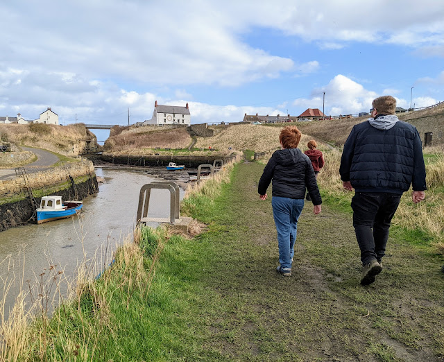
How beautiful is Holywell Dene? I can't believe we've never visited before and it's right on our doorstep. We walked part of the route which took around 40 minutes on our visit but I know from looking at the map that there are more designated footpaths around the area and I can't wait to return with Fozzy and explore further.

The online interactive map is really easy to use and navigate. Handy features include:
- The use of Geolocation (if activated) to pinpoint where you are on the map
- A 'layers' option so you can filter the map to only show cycling or traffic-free cycling routes
- A handy key which shows Metro stations, footpaths, NCN routes, on-road and traffic-free cycling routes
- The ability to click on some of the map symbols (for example Metro stations) and find out more information such as address/links to timetables

The smaller regional maps which you can download to your phone are brilliant too. How fab having instant access to so many walking and cycling routes in your pocket!
We spend a lot of time visiting different areas of the North East which we aren't too familiar with and I know with Fozzy (our puppy) in tow, I will be looking for walking routes using the maps wherever we are visiting.
The interactive and downloadable maps are so good for this. In fact we are visiting an attraction in Allendale with Fozzy on Friday and I have already checked the interactive map out to look for quick walking routes in the area.
You can download your own regional maps here.

Back to our walk and we certainly picked a lovely day for it. Here are a few photos from Holywell Dene / Seaton Sluice. The route was full of surprises and we stumbled upon a swing, a few beautiful waterfalls, lots of wildlife (the air was filled with the sound of birds tweeting) and a fantastic bridge for playing pooh sticks on.


Having access to the map we downloaded (or using our phone data to view the interactive map online) during our walk was definitely an added bonus. Jack took charge and regularly checked we were on the correct route and it was a nice way to get the kids more involved with the walk.
It's worth noting that details contained in this map are based on the latest information available at the time of publication. Whilst every effort has been made by Transport North East to ensure the accuracy of this information, they cannot accept any liability resulting in omissions or inaccuracies.
You are also advised to check with local authorities for road / route closures / works before setting off.


I know lots of readers are interested in traffic-free cycling routes and I the 'layers' aspect of the interactive map shows this perfectly. The route we walked around Holywell Dene was a footpath rather than a cycle route (and this was correct - I definitely wouldn't take a bike around there) but I have shared a random screenshot showing the traffic free routes from another area below to give you an idea of how they show up on the map.


If you're keen to cycle / walk more this year and are looking for ways to include more active travel into your daily lives, whether this be a family walk with the dog like us, a place you can safely cycle with the kids or your commute or trip to the shops or perhaps you'd like to plan a longer route across regional boundaries, the Go Smarter, Go Active website is a brilliant place to get planning.
You can view / download the Cycling & Walking Maps here.
You can view / download the Cycling & Walking Maps here.
I will leave you with more photos from Holywell Dene. What a gem. Our dog Fozzy is able to join us on walks in a few days and I cannot wait to discover more local walks like this with the help of Go Smarter, Go Active this year.
You can't beat fresh air and family time and finding a new local walk to try together/getting the kids involved in using the interactive maps to find a new route to try is a completely free activity.


No comments
Post a Comment